NOAA Chart 12312: Delaware River - Wilmington to Philadelphia
$23.75
The chart you are viewing is NOT updated weekly and does NOT include all of the latest Notice to Mariners corrections. Region: Mid-Atlantic Paper Size: 47" x 36" Chart Image Size: 33" x 44" Scale: 1:40,000 Captain's Nautical...
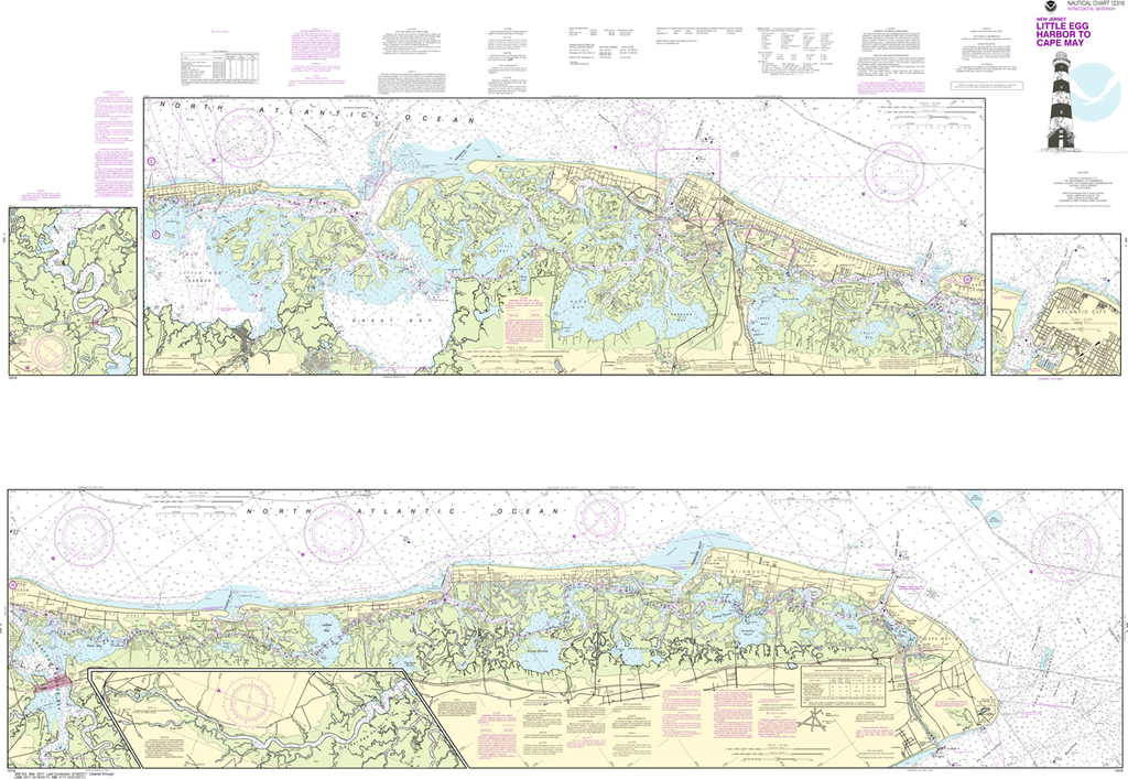
NOAA Chart 12316: Intracoastal Waterway - Little Egg Harbor to Cape May, Atlantic City
$23.75
The chart you are viewing is NOT updated weekly and does NOT include all of the latest Notice to Mariners corrections. Region: Mid-Atlantic Latest Edition: 37 Ed. (1-Oct-2018) Last Correction: 19-Nov-2019 Cleared Through: NTM 47/2019 (23-Nov-2019) ...
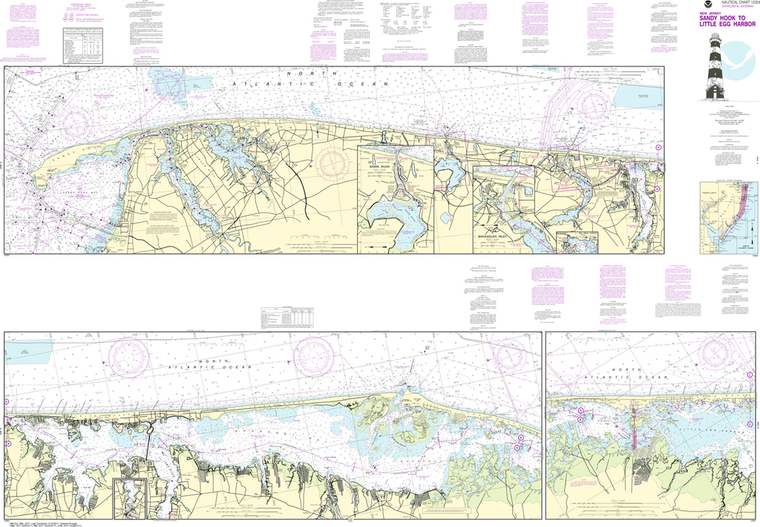
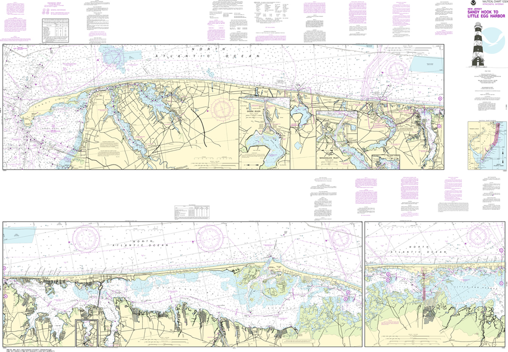
NOAA Chart 12324: Intracoastal Waterway - Sandy Hook to Little Egg Harbor
$23.75
The chart you are viewing is NOT updated weekly and does NOT include all of the latest Notice to Mariners corrections. Region: Mid-Atlantic Latest Edition: 37 Ed. (1-Dec-2018) Last Correction: 5-Nov-2019 Cleared Through: NTM 47/2019 (23-Nov-2019)...
The chart you are viewing is NOT updated weekly and does NOT include all of the latest Notice to Mariners corrections. Region: Northeast Atlantic Latest Edition: 108 Ed. (1-Nov-2018) Last Correction: 20-Dec-2019 Cleared Through: NTM 47/2019 (23-Nov-2019)...
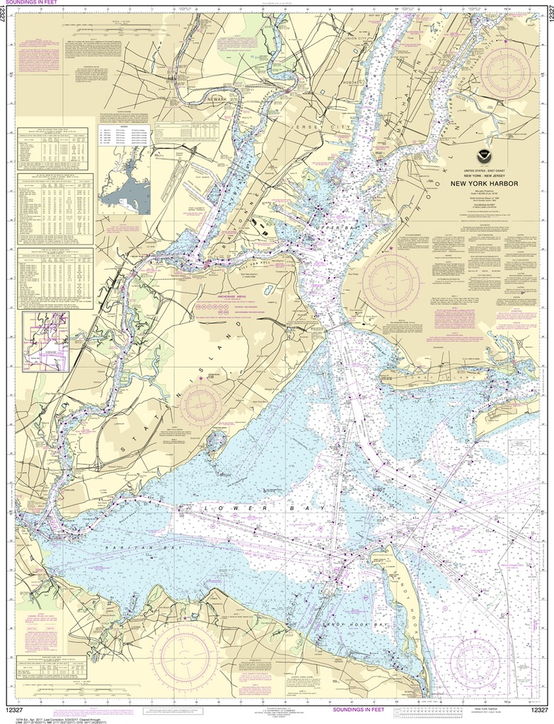
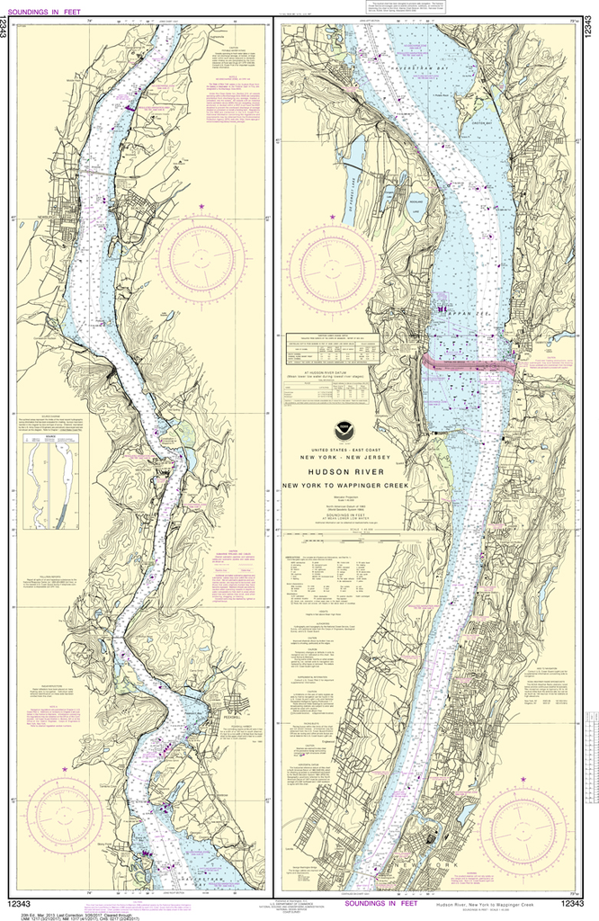
NOAA Chart 12343: Hudson River - New York to Wappinger Creek
$23.75
The chart you are viewing is NOT updated weekly and does NOT include all of the latest Notice to Mariners corrections. Region: Northeast Atlantic Latest Edition: 20 Ed. (1-Mar-2013) Last Correction: 26-Aug-2019 Cleared Through: NTM 47/2019...
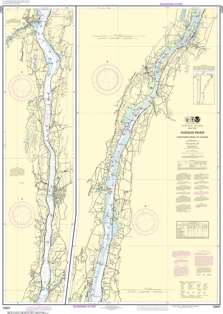
NOAA Chart 12347: Hudson River - Wappinger Creek to Hudson
$23.75
The chart you are viewing is NOT updated weekly and does NOT include all of the latest Notice to Mariners corrections. Region: Northeast Atlantic Latest Edition: 32 Ed. (1-Feb-2017) Last Correction: 20-Dec-2019 Cleared Through: NTM 47/2019...
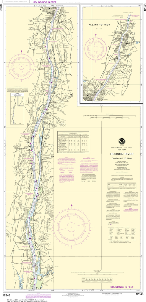
NOAA Chart 12348: Hudson River - Coxsackie to Troy
$23.75
The chart you are viewing is NOT updated weekly and does NOT include all of the latest Notice to Mariners corrections. Region: Great Lakes Latest Edition: 34 Ed. (1-Jun-2010) Last Correction: 12-Sep-2018 Cleared Through: NTM 47/2019...
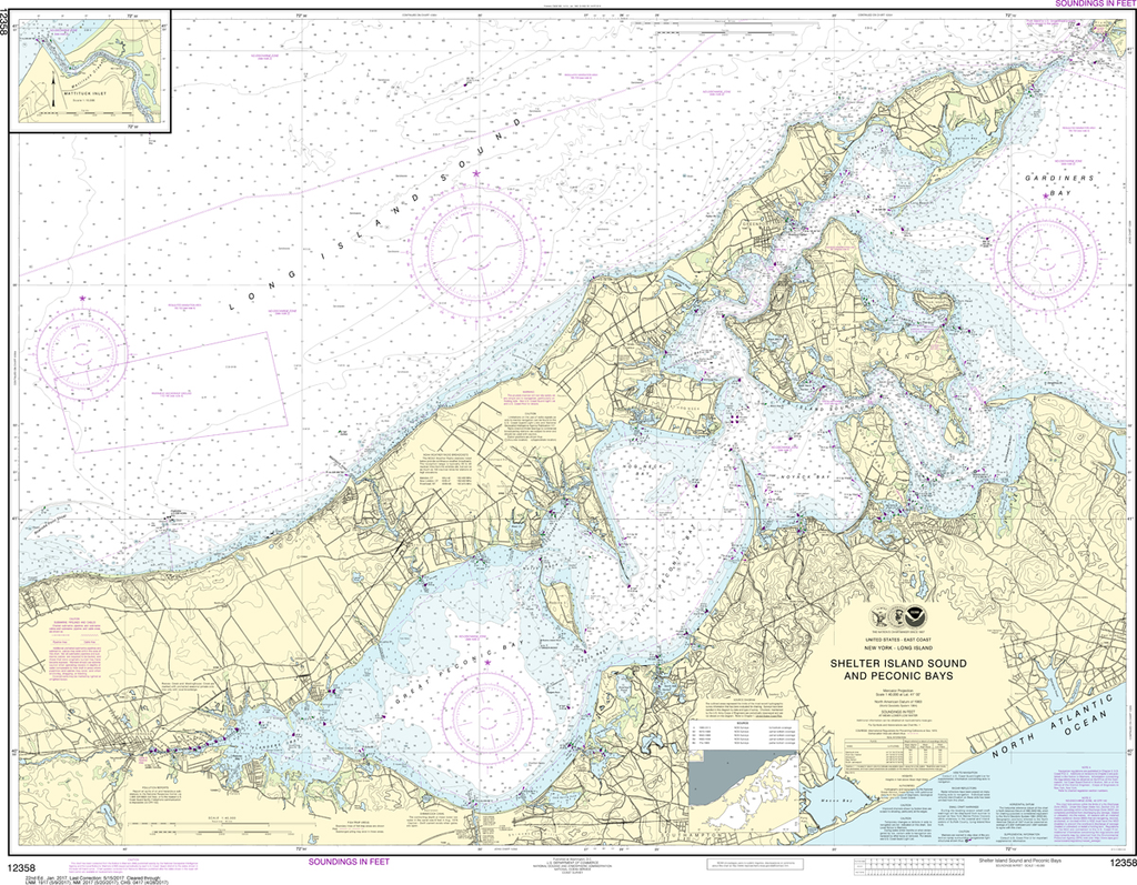
NOAA Chart 12358: New York - Long Island to Shelter Island Sound and Peconic Bays, Mattituck Inlet
$23.75
The chart you are viewing is NOT updated weekly and does NOT include all of the latest Notice to Mariners corrections. Region: Northeast Atlantic Latest Edition: 23 Ed. (1-Apr-2019) Last Correction: 25-Nov-2019 Cleared Through: NTM 47/2019...
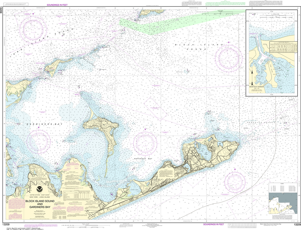
NOAA Chart 13209: Block Island Sound and Gardiners Bay, Montauk Harbor
$23.75
The chart you are viewing is NOT updated weekly and does NOT include all of the latest Notice to Mariners corrections. Region: Northeast Atlantic Latest Edition: 28 Ed. (1-Aug-2017) Last Correction: 6-Sep-2019 Cleared Through: NTM 47/2019 (23-Nov-2019)...
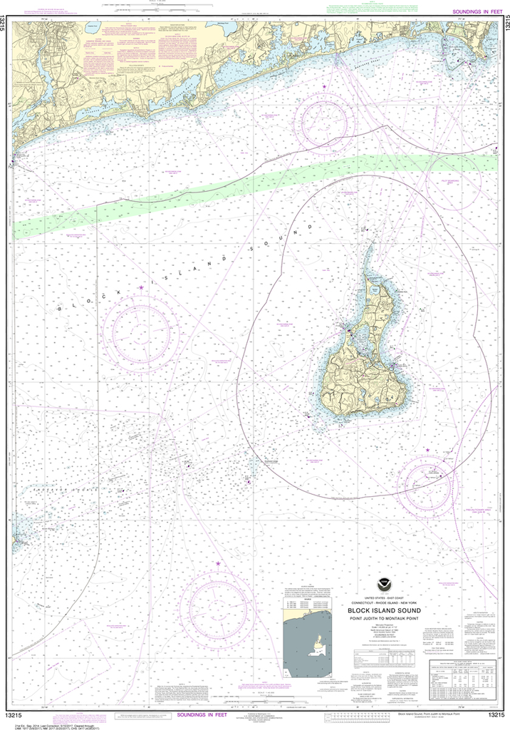
NOAA Chart 13215: Block Island Sound - Point Judith to Montauk Point
$23.75
The chart you are viewing is NOT updated weekly and does NOT include all of the latest Notice to Mariners corrections. Region: Northeast Atlantic Latest Edition: 21 Ed. (1-Sep-2014) Last Correction: 28-May-2019 Cleared Through: NTM 47/2019 (23-Nov-2019)...
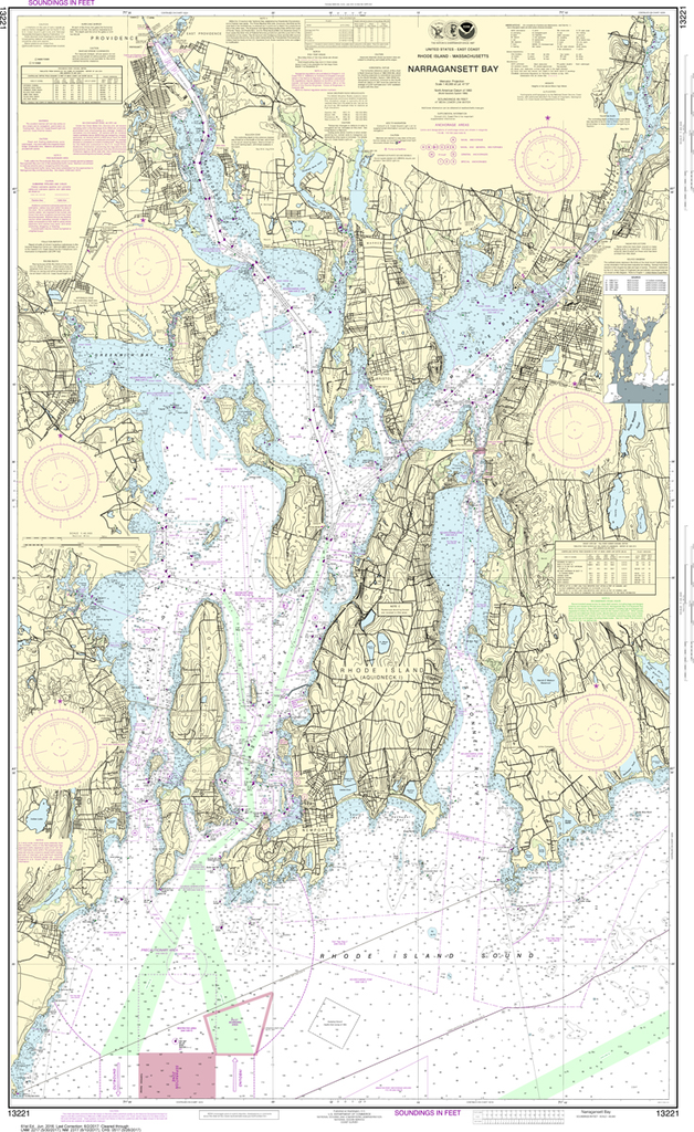
The chart you are viewing is NOT updated weekly and does NOT include all of the latest Notice to Mariners corrections. Region: Northeast Atlantic Latest Edition: 63 Ed. (1-Jun-2019) Last Correction: 31-Dec-2019 Cleared Through: NTM 47/2019 (23-Nov-2019)...
The chart you are viewing is NOT updated weekly and does NOT include all of the latest Notice to Mariners corrections. Region: Northeast Atlantic Latest Edition: 53 Ed. (1-Feb-2019) Last Correction: 23-Dec-2019 Cleared Through: NTM 47/2019 (23-Nov-2019)...
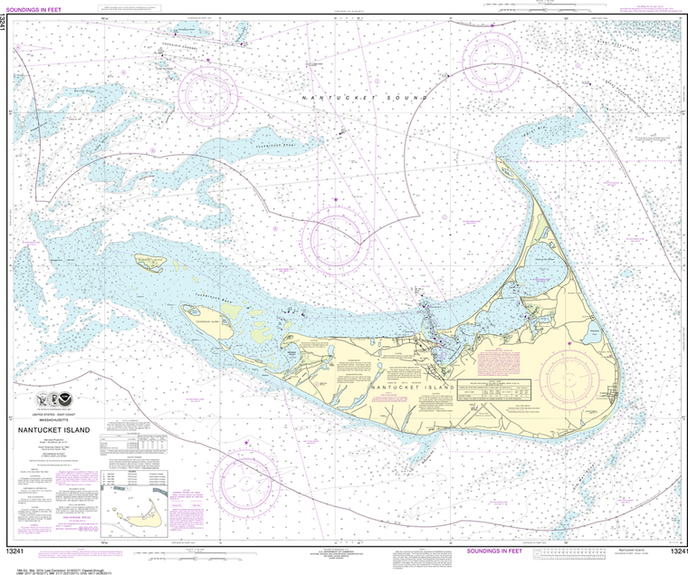
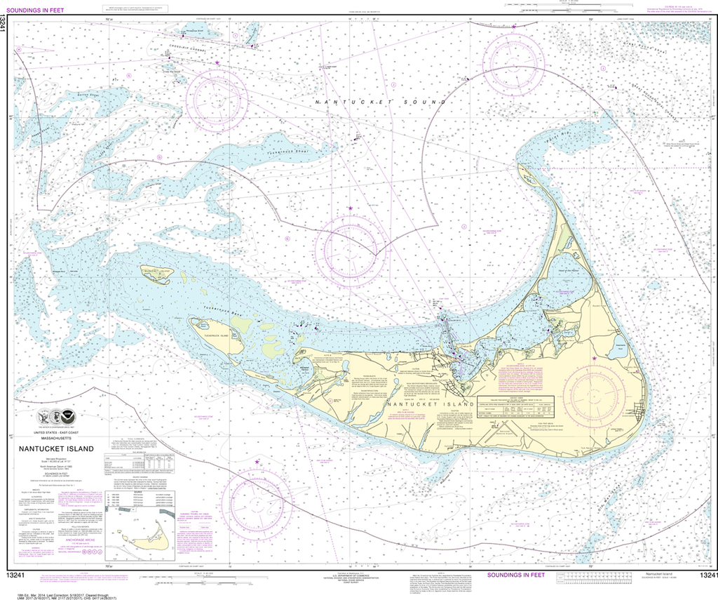
The chart you are viewing is NOT updated weekly and does NOT include all of the latest Notice to Mariners corrections. Region: Northeast Atlantic Latest Edition: 19 Ed. (1-Nov-2019) Last Correction: 13-Dec-2019 Cleared Through: NTM 47/2019 (23-Nov-2019)...
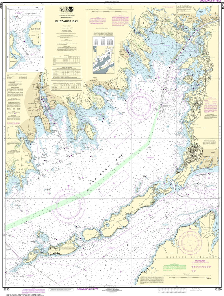
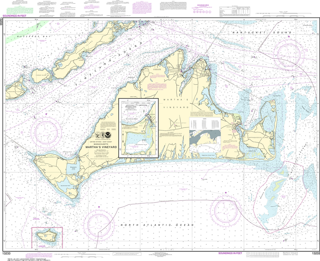
The chart you are viewing is NOT updated weekly and does NOT include all of the latest Notice to Mariners corrections. Region: Northeast Atlantic Paper Size: 45" x 36" Chart Image Size: 34" x 41" Scale: 1:40,000...
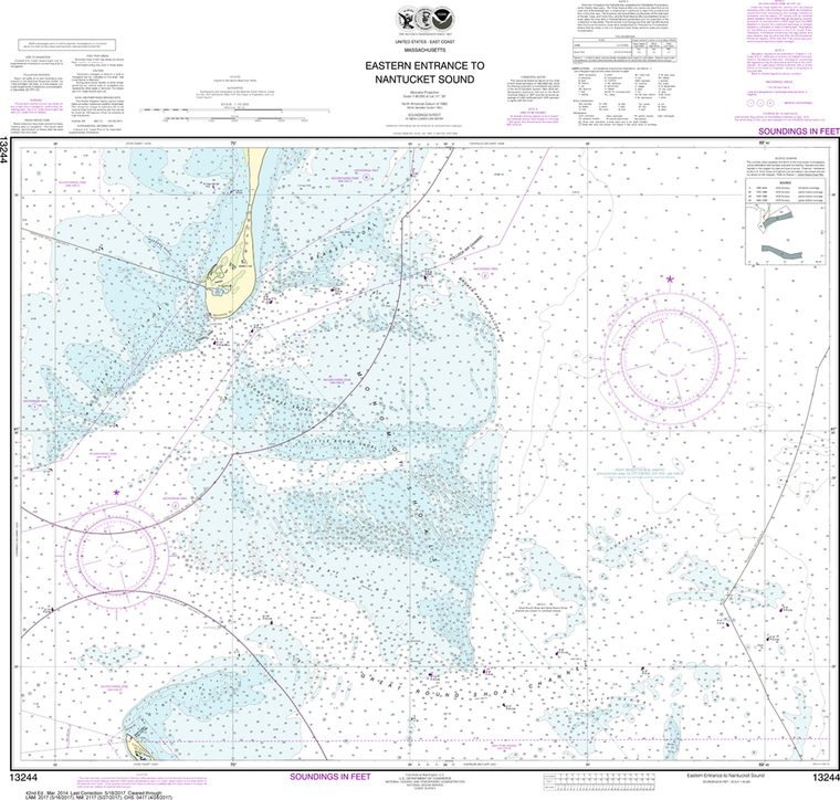
NOAA Chart 13244: Eastern Entrance to Nantucket Sound
$23.75
The chart you are viewing is NOT updated weekly and does NOT include all of the latest Notice to Mariners corrections. Region: Northeast Atlantic Latest Edition: 42 Ed. (1-Mar-2014) Last Correction: 2-Oct-2019 Cleared Through: NTM 47/2019 (23-Nov-2019)...
The chart you are viewing is NOT updated weekly and does NOT include all of the latest Notice to Mariners corrections. Region: Northeast Atlantic Latest Edition: 9 Ed. (1-Dec-2010) Last Correction: 12-Aug-2019 Cleared Through: NTM 47/2019 (23-Nov-2019)...
The chart you are viewing is NOT updated weekly and does NOT include all of the latest Notice to Mariners corrections. Region: Northeast Atlantic Latest Edition: 66 Ed. (1-Dec-2018) Last Correction: 6-Dec-2019 Cleared Through: NTM 47/2019 (23-Nov-2019)...
NOAA Chart 13274: Portsmouth Harbor to Boston Harbor, Merrimack River Extension
$23.75
The chart you are viewing is NOT updated weekly and does NOT include all of the latest Notice to Mariners corrections. Region: Northeast Atlantic Latest Edition: 30 Ed. (1-Nov-2018) Last Correction: 6-Jan-2020 Cleared Through: NTM 47/2019 (23-Nov-2019)...
NOAA Chart 13275: Salem and Lynn Harbors, Manchester Harbor
$23.75
The chart you are viewing is NOT updated weekly and does NOT include all of the latest Notice to Mariners corrections. Region: Northeast Atlantic Latest Edition: 32 Ed. (1-Nov-2013) Last Correction: 15-Oct-2019 Cleared Through: NTM 47/2019 (23-Nov-2019)...
The chart you are viewing is NOT updated weekly and does NOT include all of the latest Notice to Mariners corrections. Region: Northeast Atlantic Latest Edition: 41 Ed. (1-Oct-2019) Last Correction: 9-Oct-2019 Cleared Through: NTM 47/2019...
NOAA Chart 13293: Damariscotta, Sheepscot and Kennebec Rivers, South Bristol Harbor, Christmas Cove
$23.75
The chart you are viewing is NOT updated weekly and does NOT include all of the latest Notice to Mariners corrections. Region: Northeast Atlantic Latest Edition: 36 Ed. (1-Mar-2016) Last Correction: 25-Nov-2019 Cleared Through: NTM 47/2019...
NOAA Chart 13301: Muscongus Bay, New Harbor, Thomaston
$23.75
The chart you are viewing is NOT updated weekly and does NOT include all of the latest Notice to Mariners corrections. Region: Northeast Atlantic Latest Edition: 22 Ed. (1-Dec-2018) Last Correction: 11-Dec-2018 Cleared Through: NTM 47/2019 (23-Nov-2019)...
The chart you are viewing is NOT updated weekly and does NOT include all of the latest Notice to Mariners corrections. Region: Northeast Atlantic Paper Size: 47" x 36" Chart Image Size: 35" x 43" Scale: 1:40,000 Captain's...
NOAA Chart 13305: Penobscot Bay, Carvers Harbor and Approaches
$23.75
The chart you are viewing is NOT updated weekly and does NOT include all of the latest Notice to Mariners corrections. Region: Northeast Atlantic Latest Edition: 31 Ed. (1-Nov-2017) Last Correction: 1-Jul-2019 Cleared Through: NTM 47/2019...