NOAA Chart 11511: Ossabaw and St. Catherines Sounds
$23.75
Region: Mid-Atlantic Paper Size: 47" x 36" Chart Image Size: 33" x 43" Scale: 1:40,000 Captain's Nautical Supplies is a Print-on-Demand nautical chart dealer for US Waters. All charts are printed up-to-date and corrected to the...
The chart you are viewing is NOT updated weekly and does NOT include all of the latest Notice to Mariners corrections. Region: Mid-Atlantic Latest Edition: 65 Ed. (1-Sep-2017) Last Correction: 13-Dec-2019 Cleared Through: NTM 47/2019 (23-Nov-2019) ...
NOAA Chart 11516: Port Royal Sound and Inland Passages
$23.75
The chart you are viewing is NOT updated weekly and does NOT include all of the latest Notice to Mariners corrections. Region: Mid-Atlantic Latest Edition: 32 Ed. (1-Dec-2013) Last Correction: 13-Aug-2019 Cleared Through: NTM 47/2019 (23-Nov-2019) ...
Region: Mid-Atlantic Paper Size: 49" x 36" Chart Image Size: 46" x 31" Scale: 1:40,000 Captain's Nautical Supplies is a Print-on-Demand nautical chart dealer for US Waters. All charts are printed up-to-date and corrected to the...
NOAA Chart 11518: Intracoastal Waterway - Casino Creek to Beaufort River
$23.75
The chart you are viewing is NOT updated weekly and does NOT include all of the latest Notice to Mariners corrections. Region: Mid-Atlantic Latest Edition: 38 Ed. (1-May-2012) Last Correction: 13-Aug-2019 Cleared Through: NTM 47/2019 (23-Nov-2019) ...
NOAA Chart 11528: Charleston Harbor Entrance and Approach
$23.75
The chart you are viewing is NOT updated weekly and does NOT include all of the latest Notice to Mariners corrections. Region: Mid-Atlantic Latest Edition: 3 Ed. (1-Mar-2019) Last Correction: 13-Aug-2019 Cleared Through: NTM 47/2019 (23-Nov-2019) ...
The chart you are viewing is NOT updated weekly and does NOT include all of the latest Notice to Mariners corrections. Region: Mid-Atlantic Latest Edition: 23 Ed. (1-Sep-2019) Last Correction: 17-Sep-2019 Cleared Through: NTM 47/2019 (23-Nov-2019) ...
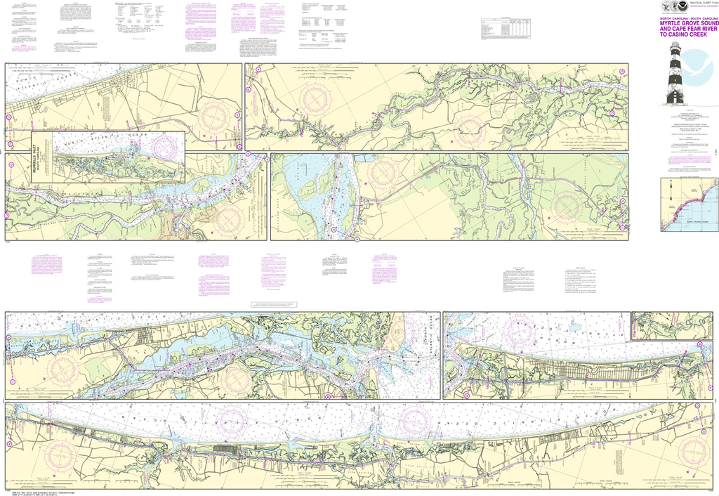
NOAA Chart 11534: Intracoastal Waterway - Myrtle Grove Sound and Cape Fear River to Casino Creek
$23.75
The chart you are viewing is NOT updated weekly and does NOT include all of the latest Notice to Mariners corrections. Region: Mid-Atlantic Paper Size: 62" x 42" Chart Image Size: 41" x 59" Scale: 1:40,000 ...
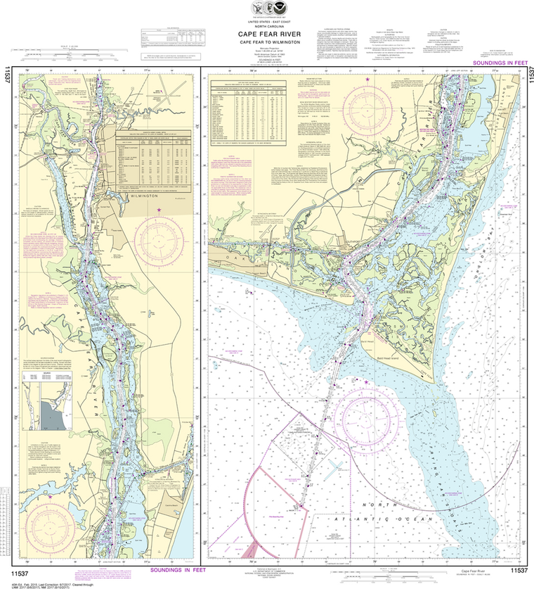
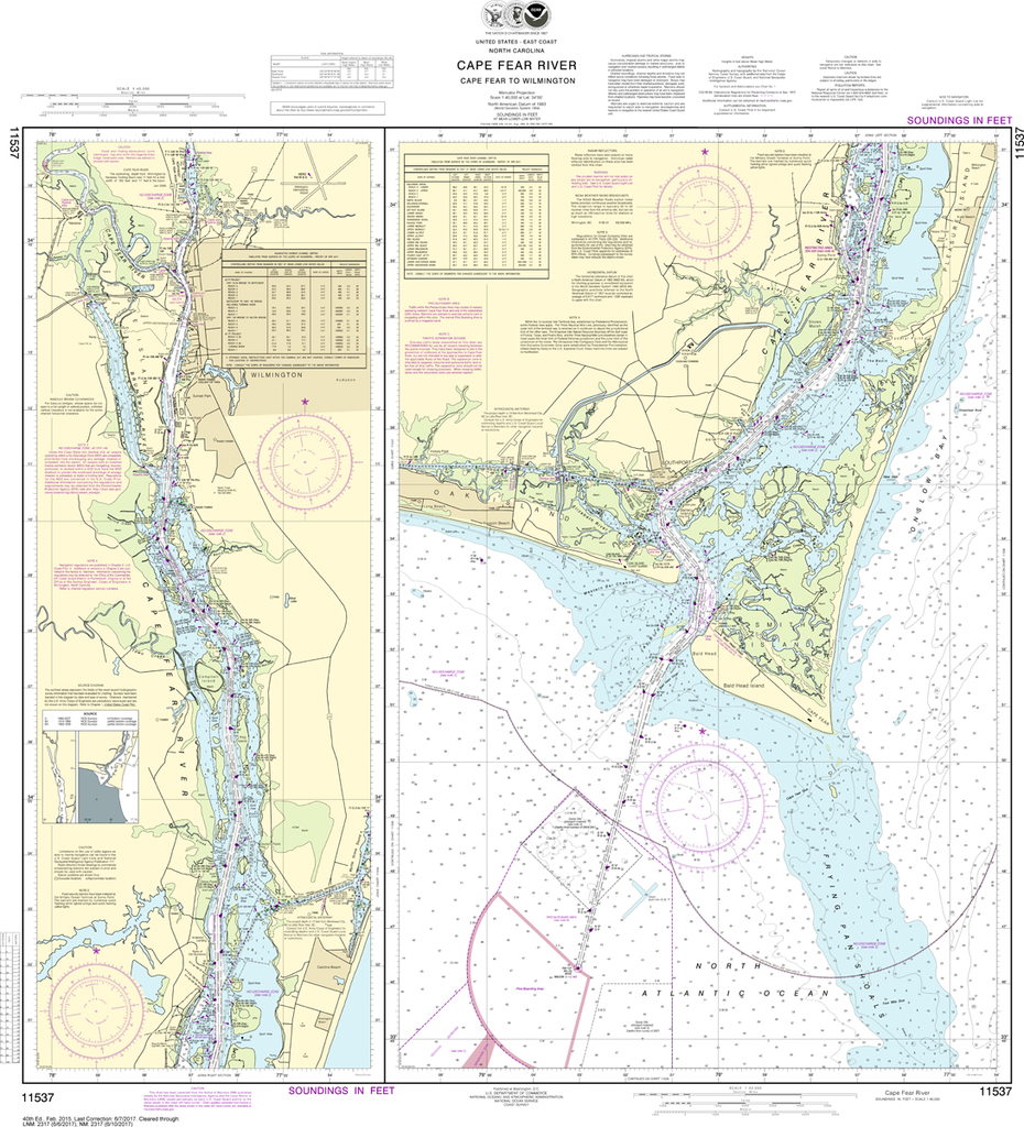
NOAA Chart 11537: Cape Fear River - Cape Fear to Wilmington
$23.75
The chart you are viewing is NOT updated weekly and does NOT include all of the latest Notice to Mariners corrections. Region: Mid-Atlantic Latest Edition: 40 Ed. (1-Feb-2015) Last Correction: 12-Nov-2019 Cleared Through: NTM 47/2019 (23-Nov-2019) ...
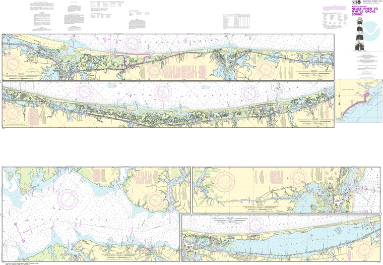
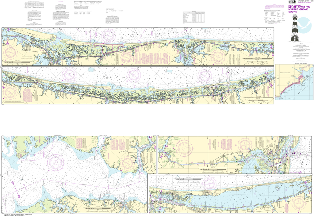
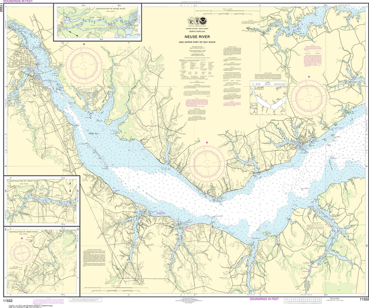
NOAA Chart 11541: Intracoastal Waterway - Neuse River to Myrtle Grove Sound
$23.75
The chart you are viewing is NOT updated weekly and does NOT include all of the latest Notice to Mariners corrections.
Region: Mid-Atlantic Paper Size: 62" x 42" Chart Image Size: 41" x 59" Scale: 1:40,000
The chart you are viewing is NOT updated weekly and does NOT include all of the latest Notice to Mariners corrections. Region: Mid-Atlantic Latest Edition: 20 Ed. (1-Dec-2017) Last Correction: 5-Nov-2019 Cleared Through: NTM 47/2019 (23-Nov-2019) ...
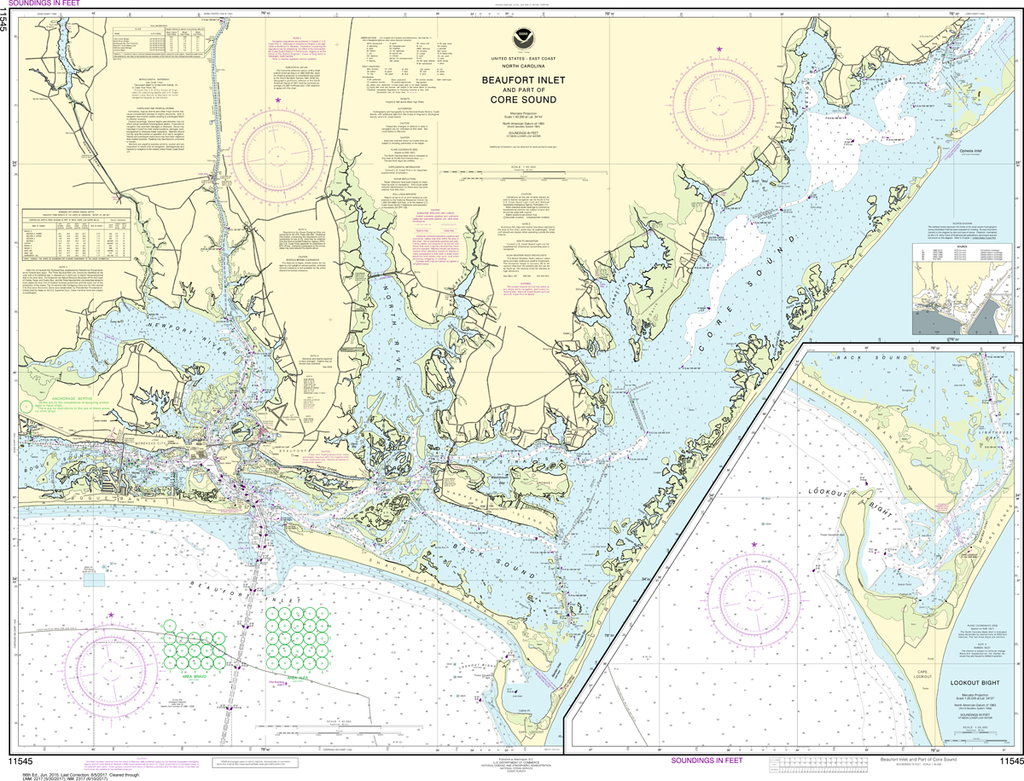
NOAA Chart 11545: Beaufort Inlet and Part of Core Sound, Lookout Bight
$23.75
The chart you are viewing is NOT updated weekly and does NOT include all of the latest Notice to Mariners corrections. Region: Mid-Atlantic Paper Size: 48" x 36" Chart Image Size: 34" x 45" Scale: 1:40,000...
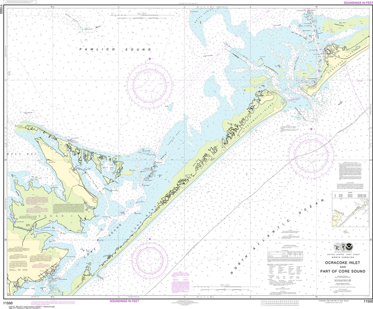
NOAA Chart 11550: Ocracoke lnlet and Part of Core Sound
$23.75
Region: Mid-Atlantic Paper Size: 46" x 36" Chart Image Size: 35" x 42" Scale: 1:40,000 Captain's Nautical Supplies is a Print-on-Demand nautical chart dealer for US Waters. All charts are printed up-to-date and corrected to the...
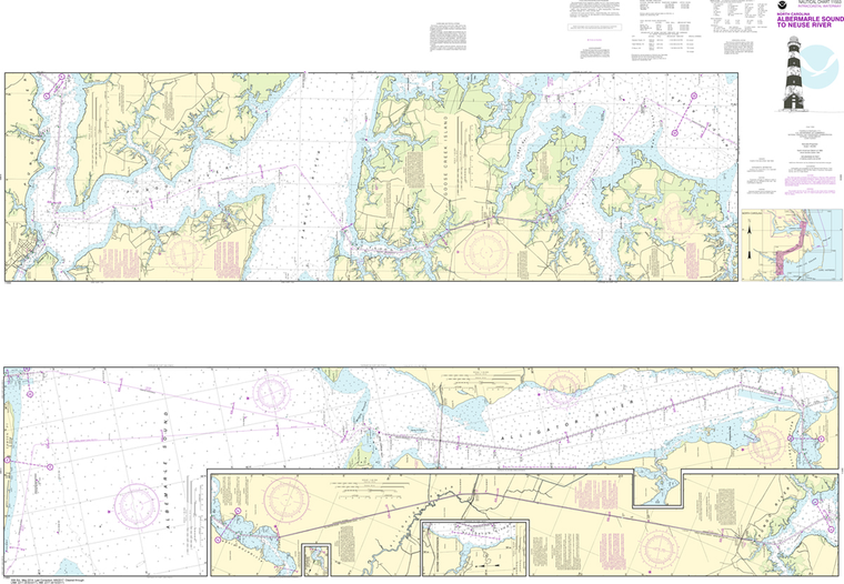
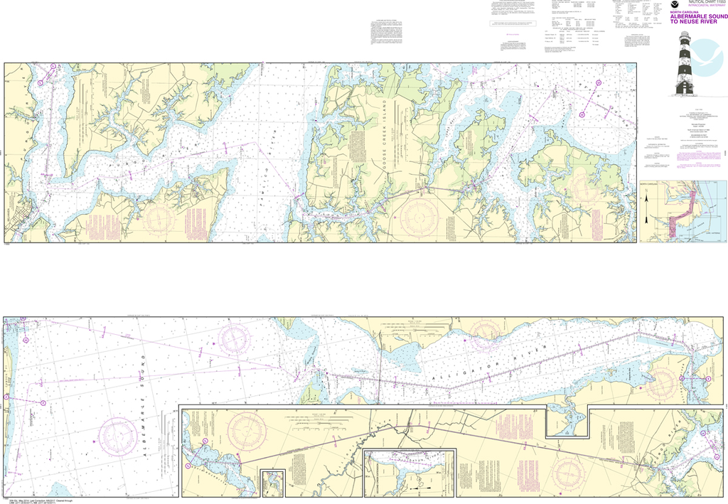
NOAA Chart 11553: Intracoastal Waterway - Albermarle Sound to Neuse River, Alligator River, Second Creek
$23.75
The chart you are viewing is NOT updated weekly and does NOT include all of the latest Notice to Mariners corrections. Region: Mid-Atlantic Paper Size: 62" x 42" Chart Image Size: 41" x 59" Scale: 1:40,000 Captain's...
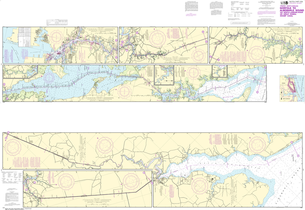
NOAA Chart 12206: Intracoastal Waterway - Norfolk to Albemarle Sound via North Landing River or Great Dismal Swamp Canal
$23.75
The chart you are viewing is NOT updated weekly and does NOT include all of the latest Notice to Mariners corrections. Region: Mid-Atlantic Paper Size: 62" x 42" Chart Image Size: 41" x 59" Scale: 1:40,000 Captain's Nautical...