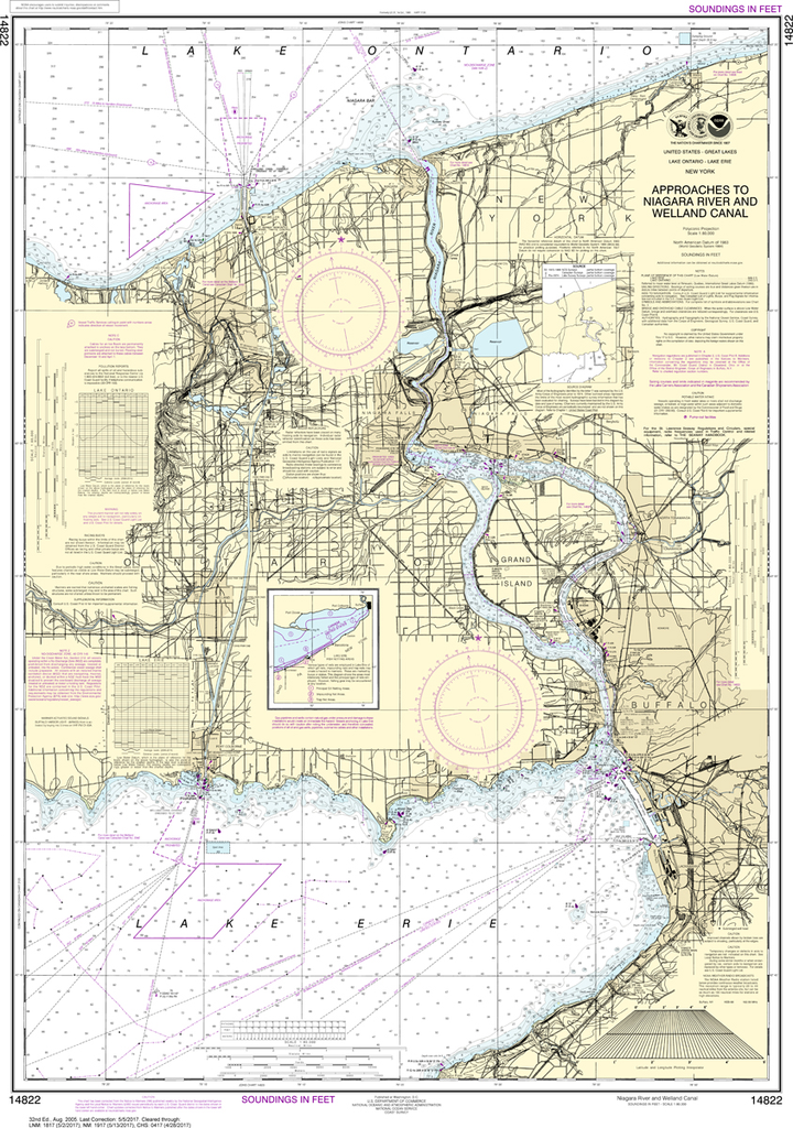
NOAA Chart 14822: Approaches to Niagara River and Welland Canal
$23.75
The chart you are viewing is NOT updated weekly and does NOT include all of the latest Notice to Mariners corrections. Region: Great Lakes Latest Edition: 32 Ed. (1-Aug-2005) Last Correction: 30-Oct-2018 Cleared Through: NTM 47/2019...
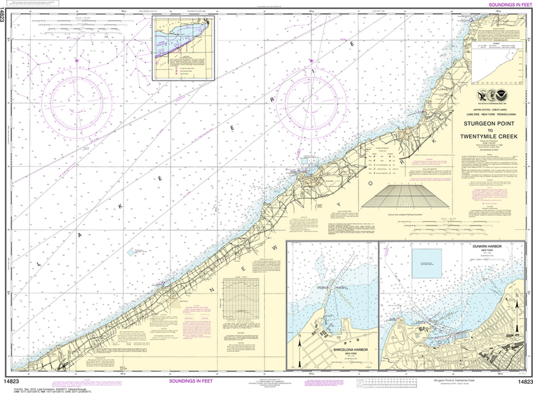
NOAA Chart 14823: Sturgeon Point to Twentymile Creek, Dunkirk Harbor, Barcelona Harbor
$23.75
The chart you are viewing is NOT updated weekly and does NOT include all of the latest Notice to Mariners corrections. Region: Great Lakes Latest Edition: 31 Ed. (1-Dec-2012) Last Correction: 30-Nov-2018 Cleared Through: NTM 47/2019 (23-Nov-2019)...
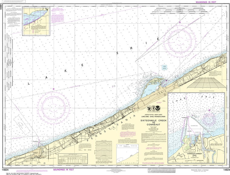
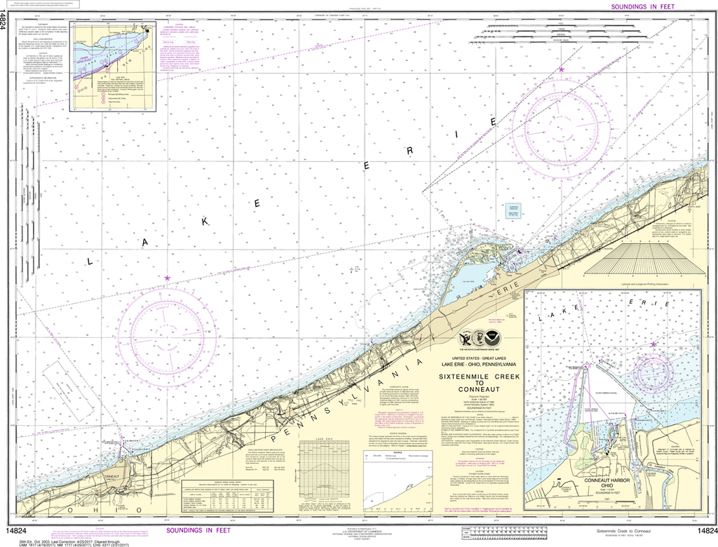
NOAA Chart 14824: Sixteenmile Creek to Conneaut, Conneaut Harbor
$23.75
The chart you are viewing is NOT updated weekly and does NOT include all of the latest Notice to Mariners corrections. Region: Great Lakes Latest Edition: 26 Ed. (1-Oct-2003) Last Correction: 30-May-2019 Cleared Through: NTM 47/2019...
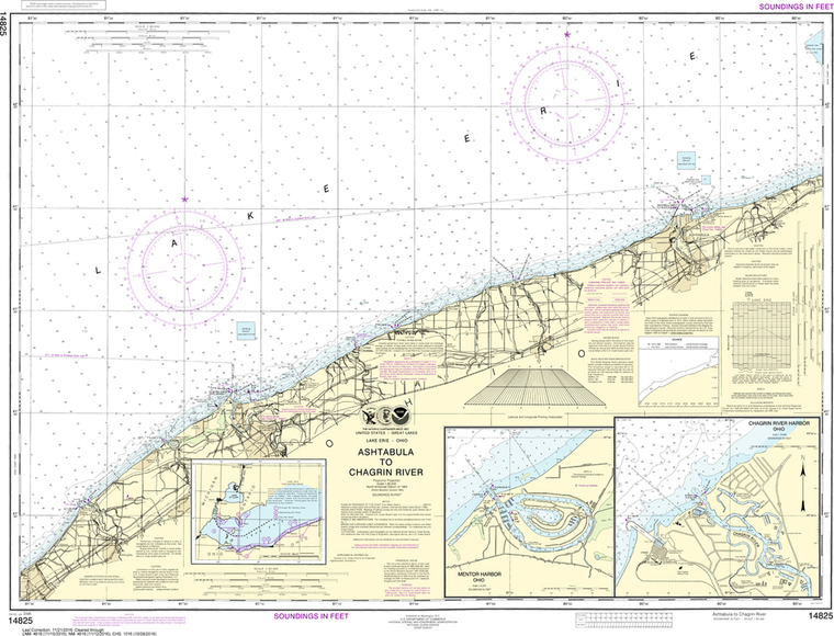
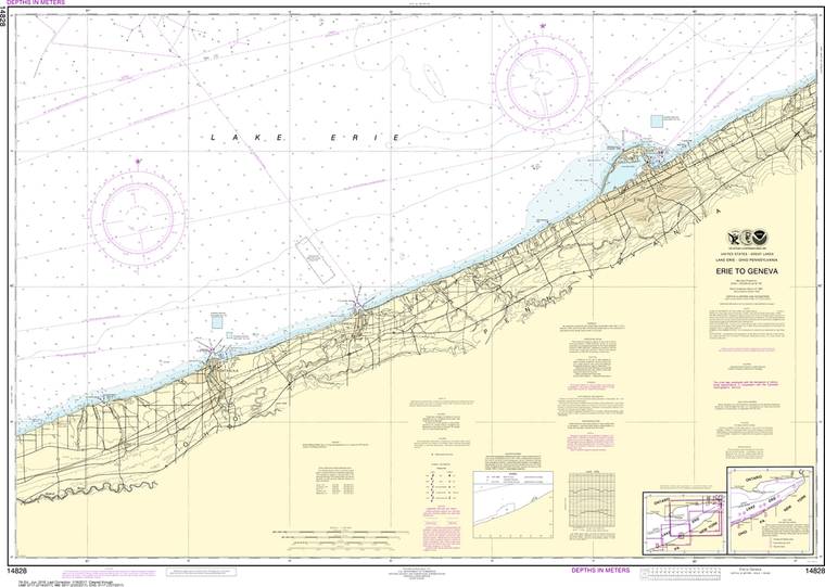
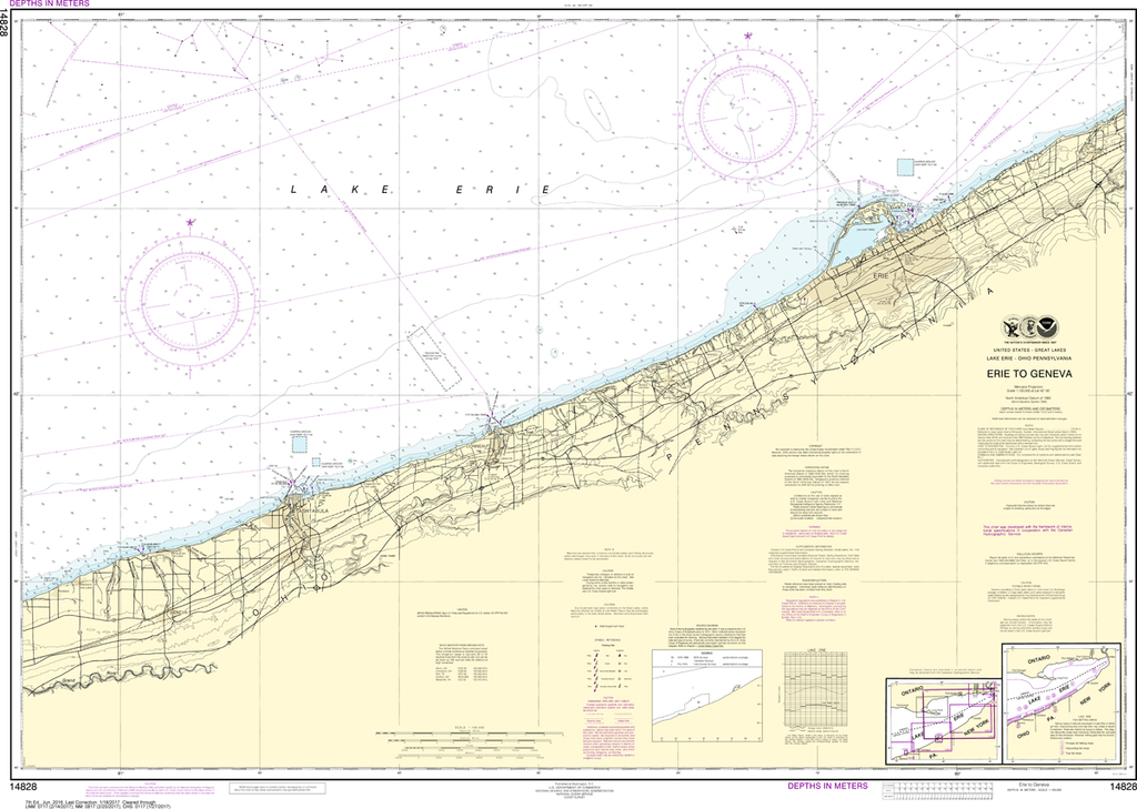
NOAA Chart 14825: Ashtabula to Chagrin River, Mentor Harbor, Chagrin River
$23.75
The chart you are viewing is NOT updated weekly and does NOT include all of the latest Notice to Mariners corrections. Region: Great Lakes Latest Edition: 25 Ed. (1-Jan-2006) Last Correction: 23-Mar-2018 Cleared Through: NTM 47/2019 (23-Nov-2019)...
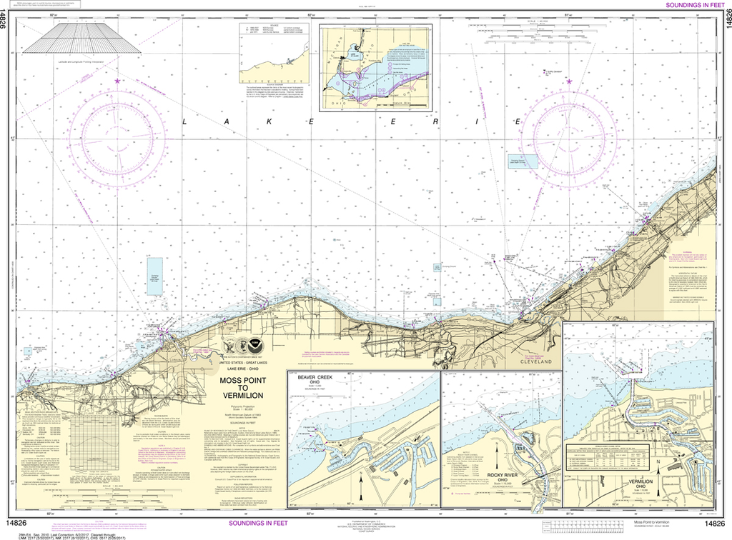
NOAA Chart 14826: Moss Point to Vermilion, Beaver Creek, Vermilion Harbor, Rocky River
$23.75
The chart you are viewing is NOT updated weekly and does NOT include all of the latest Notice to Mariners corrections. Region: Great Lakes Latest Edition: 28 Ed. (1-Sep-2010) Last Correction: 29-Nov-2019 Cleared Through: NTM 47/2019...
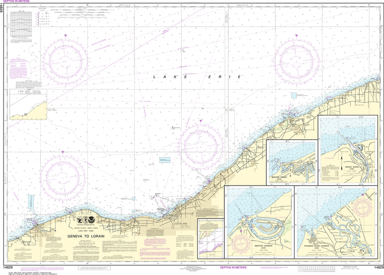
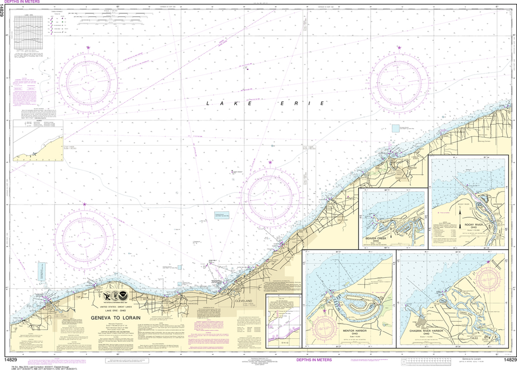
NOAA Chart 14829: Geneva to Lorain, Beaver Creek, Rocky River, Mentor Harbor, Chagrin River
$23.75
THIS CHART IS CURRENTLY CANCELED BY NOAA. We know there are many questions about NOAA charts, newest editions and charts being cancelled. The U.S. Office of Coast Survey provides an updated list of all chart updates and the ones being...
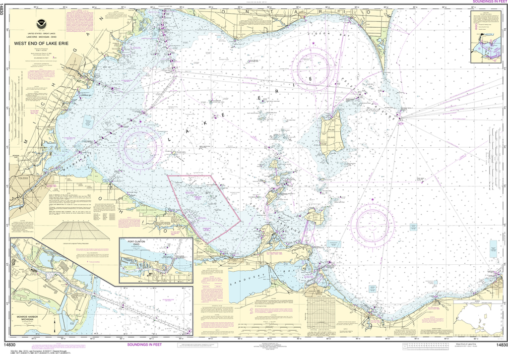
NOAA Chart 14830: West End of Lake Erie - Port Clinton Harbor, Monroe Harbor, Lorain to Detroit River, Vermilion
$23.75
The chart you are viewing is NOT updated weekly and does NOT include all of the latest Notice to Mariners corrections. Region: Great Lakes Latest Edition: 34 Ed. (1-Feb-2019) Last Correction: 18-Jul-2019 Cleared Through: NTM 47/2019 (23-Nov-2019)...
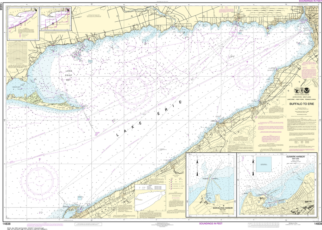
NOAA Chart 14838: Buffalo to Erie, Dunkirk, Barcelone Harbor
$23.75
THIS CHART IS CURRENTLY CANCELED BY NOAA. We know there are many questions about NOAA charts, newest editions and charts being cancelled. The U.S. Office of Coast Survey provides an updated list of all chart updates and the ones being...
The chart you are viewing is NOT updated weekly and does NOT include all of the latest Notice to Mariners corrections. Region: Great Lakes Latest Edition: 56 Ed. (1-Dec-2018) Last Correction: 26-Dec-2019 Cleared Through: NTM 47/2019 (23-Nov-2019)...
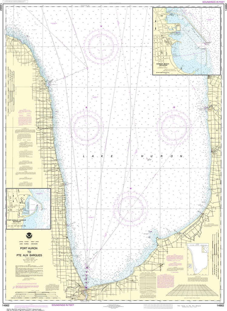
NOAA Chart 14862: Port Huron to Pointe aux Barques, Port Sanilac, Harbor Beach
$23.75
The chart you are viewing is NOT updated weekly and does NOT include all of the latest Notice to Mariners corrections. Region: Great Lakes Latest Edition: 29 Ed. (1-May-2016) Last Correction: 26-Dec-2019 Cleared Through: NTM 47/2019 (23-Nov-2019)...
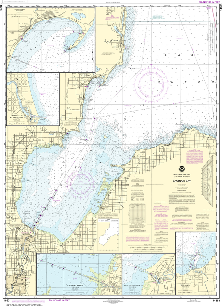
NOAA Chart 14863: Saginaw Bay, Port Austin Harbor, Caseville Harbor, Entrance to Au Sable River, Sebewaing Harbor, Tawas Harbor
$23.75
The chart you are viewing is NOT updated weekly and does NOT include all of the latest Notice to Mariners corrections. Region: Great Lakes Latest Edition: 32 Ed. (1-Mar-2014) Last Correction: 13-Nov-2018 Cleared Through: NTM 47/2019 (23-Nov-2019)...
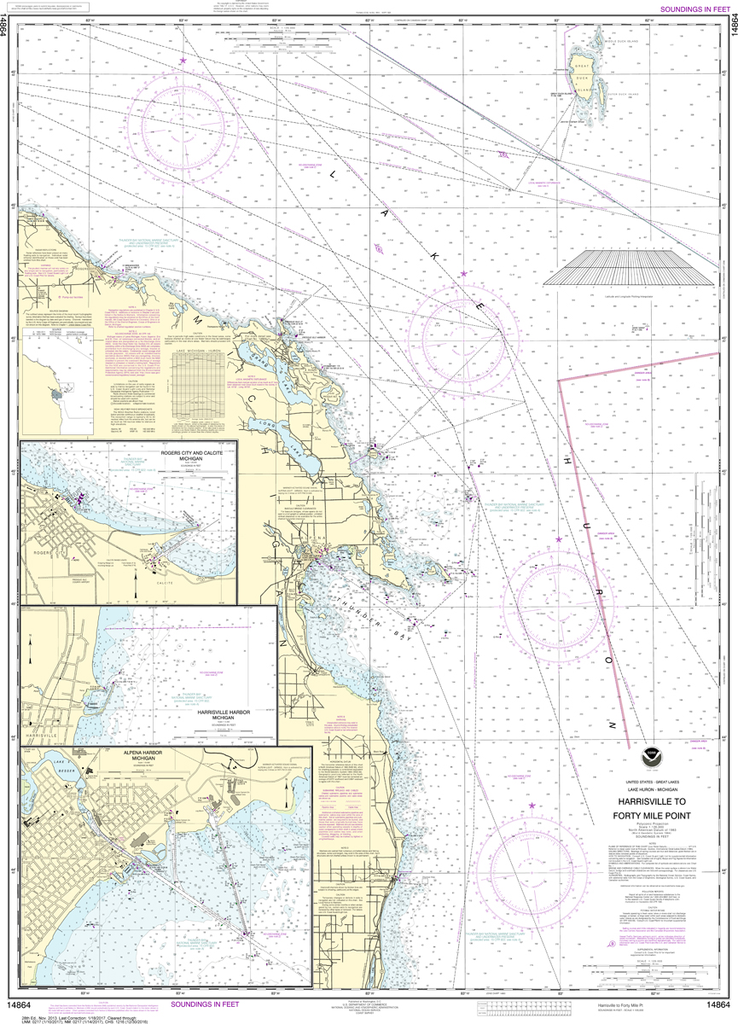
NOAA Chart 14864: Harrisville to Forty Mile Point, Harrisville Harbor, Alpena, Rogers City and Calcite
$23.75
The chart you are viewing is NOT updated weekly and does NOT include all of the latest Notice to Mariners corrections. Region: Great Lakes Latest Edition: 28 Ed. (1-Nov-2013) Last Correction: 30-Sep-2019 Cleared Through: NTM 47/2019...
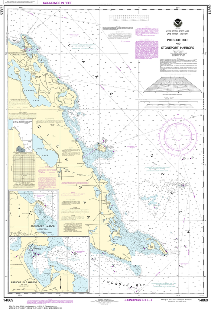
NOAA Chart 14869: Thunder Bay Island to Presque Isle, Stoneport Harbor, Resque Isle Harbor
$23.75
The chart you are viewing is NOT updated weekly and does NOT include all of the latest Notice to Mariners corrections. Region: Great Lakes Latest Edition: 27 Ed. (1-Nov-2013) Last Correction: 30-Sep-2019 Cleared Through: NTM 47/2019 (23-Nov-2019)...
The chart you are viewing is NOT updated weekly and does NOT include all of the latest Notice to Mariners corrections. Region: Great Lakes Latest Edition: 34 Ed. (1-Oct-2019) Last Correction: 29-Nov-2019 Cleared Through: NTM 47/2019 (23-Nov-2019)...
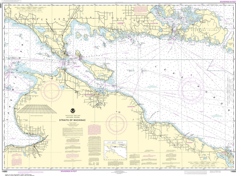
NOAA Chart 14881: Detour Passage to Waugoshance Point, Hammond Bay Harbor, Mackinac Island, Cheboygan, Mackinaw City, St. lgnace
$23.75
The chart you are viewing is NOT updated weekly and does NOT include all of the latest Notice to Mariners corrections. Region: Great Lakes Latest Edition: 36 Ed. (1-Nov-2019) Last Correction: 29-Nov-2019 Cleared Through: NTM...
NOAA Chart 14903: Algoma to Sheboygan, Kewaunee, Two Rivers
$23.75
THIS CHART IS CURRENTLY CANCELED BY NOAA. We know there are many questions about NOAA charts, newest editions and charts being cancelled. The U.S. Office of Coast Survey provides an updated list of all chart updates and the ones being...
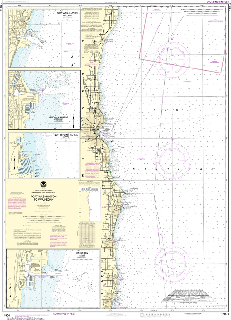
NOAA Chart 14904: Port Washington to Waukegan, Kenosha, North Point Marina, Port Washington, Waukegan
$23.75
THIS CHART IS CURRENTLY CANCELED BY NOAA. We know there are many questions about NOAA charts, newest editions and charts being cancelled. The U.S. Office of Coast Survey provides an updated list of all chart updates and the ones being...
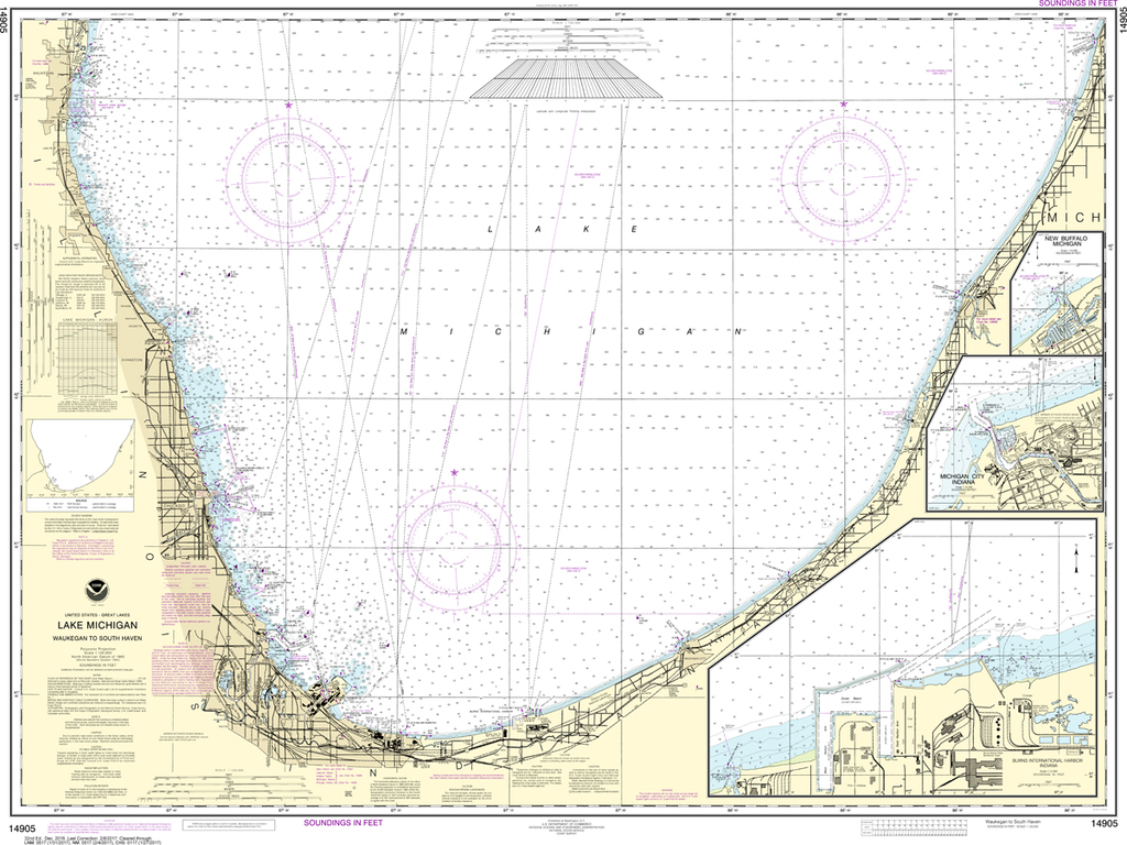
NOAA Chart 14905: Waukegan to South Haven, Michigan City, Burns International Harbor, New Buffalo
$23.75
THIS CHART IS CURRENTLY CANCELED BY NOAA. We know there are many questions about NOAA charts, newest editions and charts being cancelled. The U.S. Office of Coast Survey provides an updated list of all chart updates and the ones being...
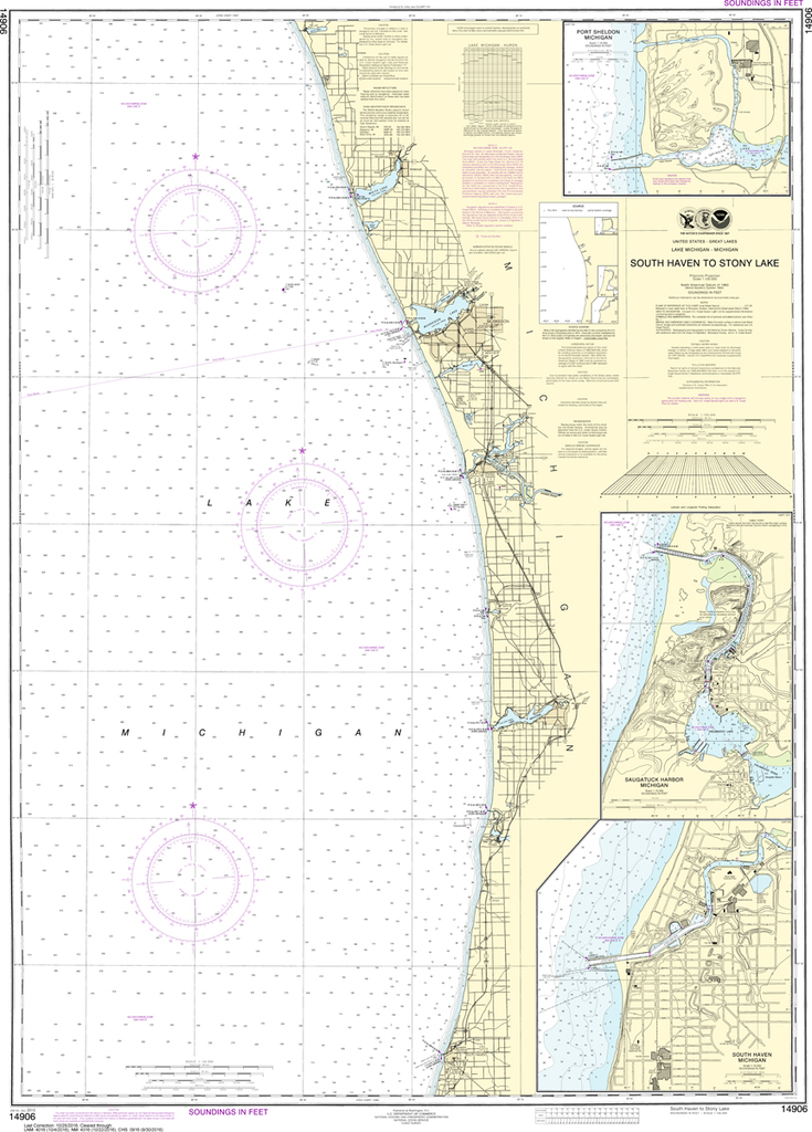
NOAA Chart 14906: South Haven to Stony Lake, South Haven, Port Sheldon, Saugatuck Harbor
$23.75
THIS CHART IS CURRENTLY CANCELED BY NOAA. We know there are many questions about NOAA charts, newest editions and charts being cancelled. The U.S. Office of Coast Survey provides an updated list of all chart updates and the ones being...
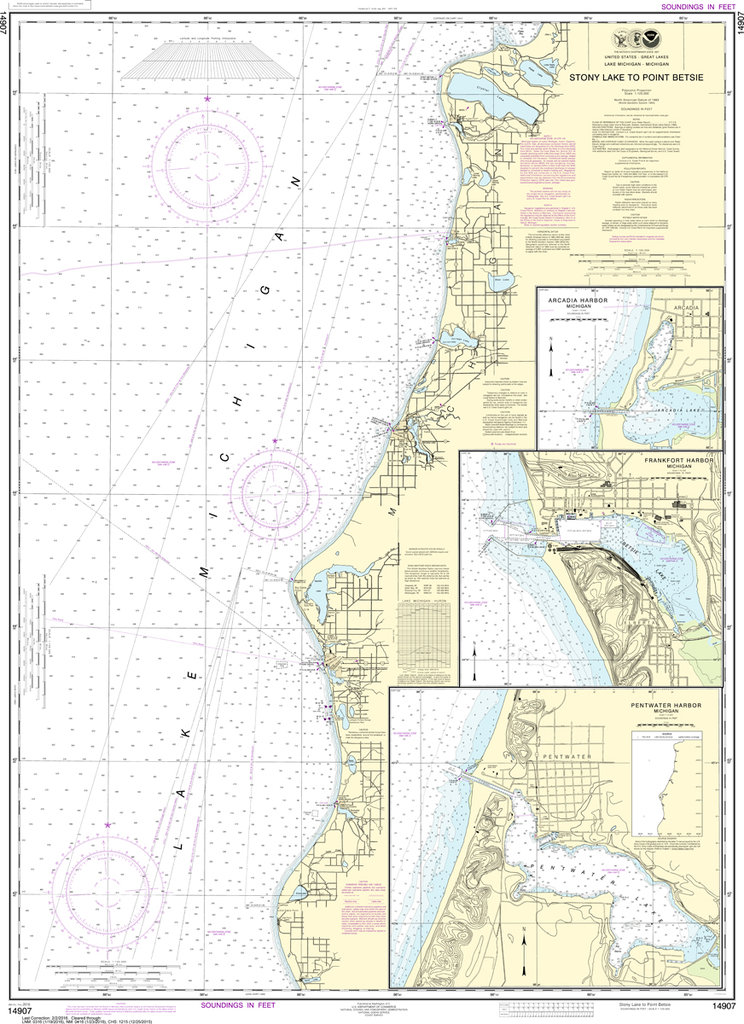
NOAA Chart 14907: Stony Lake to Point Betsie, Pentwater, Arcadia, Frankfort
$23.75
The chart you are viewing is NOT updated weekly and does NOT include all of the latest Notice to Mariners corrections. Region: Great Lakes Latest Edition: 29 Ed. (1-Sep-2017) Last Correction: 3-Sep-2019 Cleared Through: NTM 47/2019 (23-Nov-2019)...