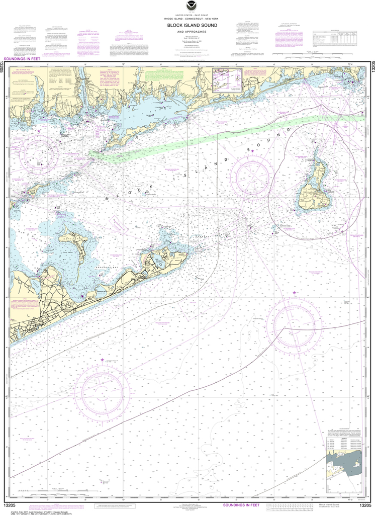
NOAA Chart 13205: Block Island Sound and Approaches
$23.75
The chart you are viewing is NOT updated weekly and does NOT include all of the latest Notice to Mariners corrections. Region: Northeast Atlantic Latest Edition: 41 Ed. (1-Feb-2017) Last Correction: 6-Sep-2019 Cleared Through: NTM 47/2019 (23-Nov-2019)...
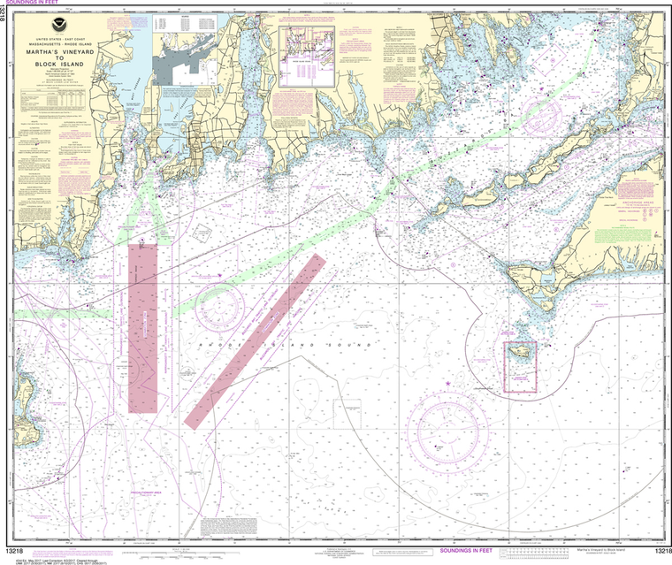
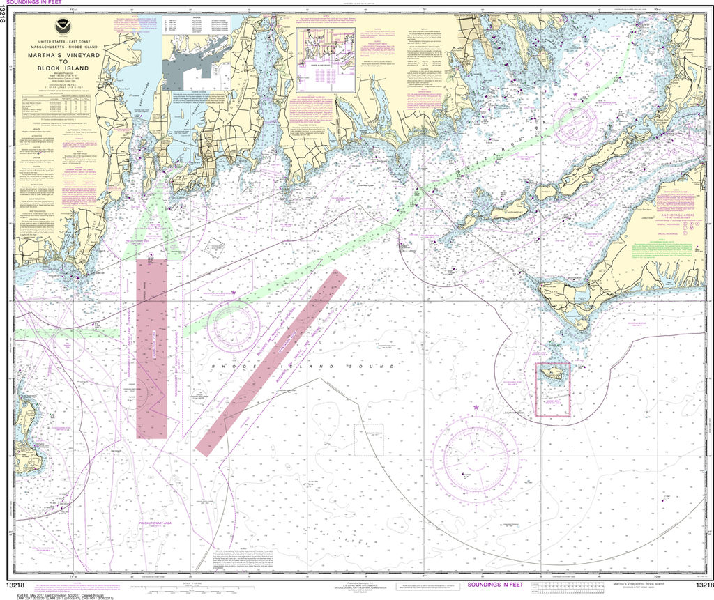
NOAA Chart 13218: Martha's Vineyard to Block Island
$23.75
The chart you are viewing is NOT updated weekly and does NOT include all of the latest Notice to Mariners corrections. Region: Northeast Atlantic Latest Edition: 44 Ed. (1-Nov-2018) Last Correction: 20-Dec-2019 Cleared Through: NTM 47/2019 (23-Nov-2019)...
The chart you are viewing is NOT updated weekly and does NOT include all of the latest Notice to Mariners corrections. Region: Northeast Atlantic Latest Edition: 44 Ed. (1-Aug-2019) Last Correction: 8-Nov-2019 Cleared Through: NTM 47/2019 (23-Nov-2019)...
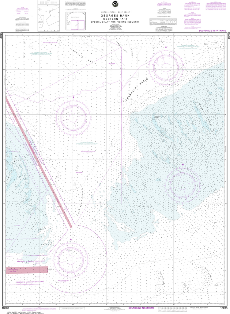
The chart you are viewing is NOT updated weekly and does NOT include all of the latest Notice to Mariners corrections. Region: Northeast Atlantic Latest Edition: 40 Ed. (1-Oct-2013) Last Correction: 16-Aug-2019 Cleared Through: NTM 47/2019 (23-Nov-2019)...
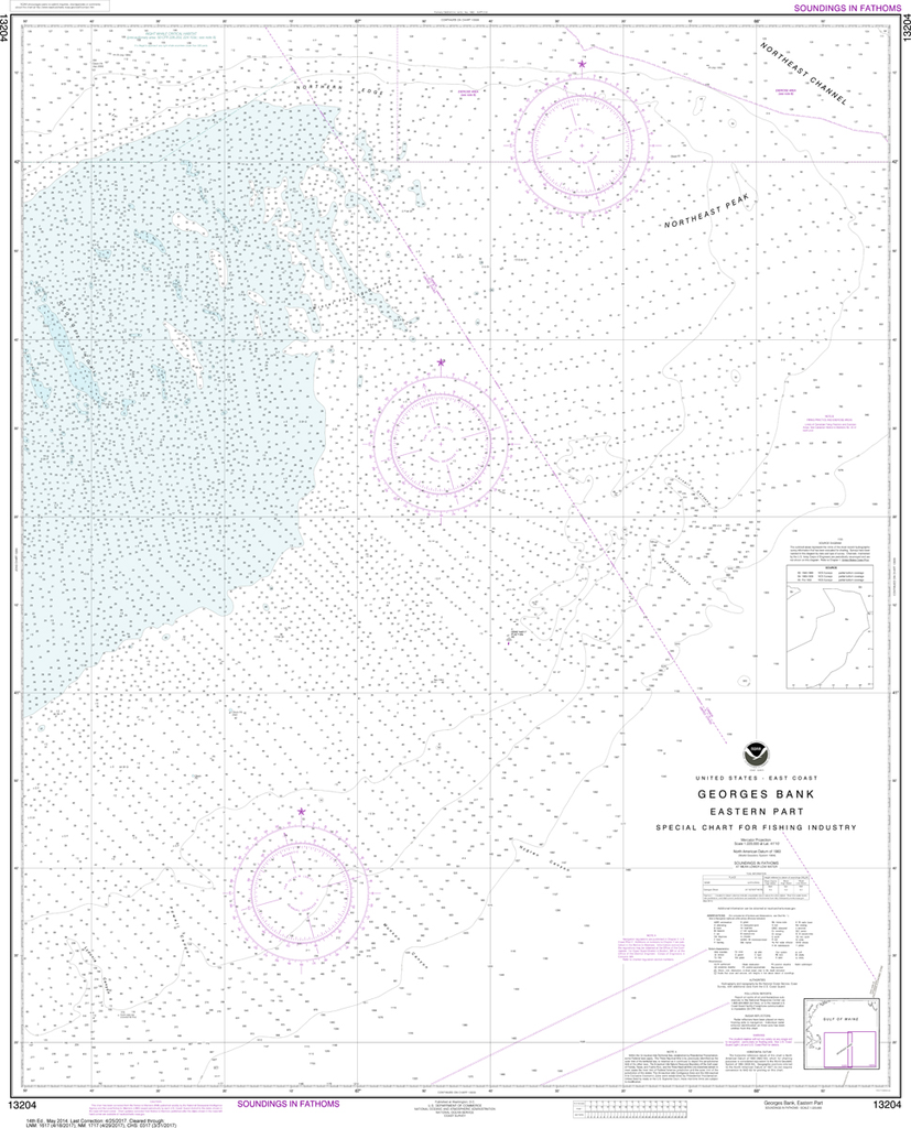
The chart you are viewing is NOT updated weekly and does NOT include all of the latest Notice to Mariners corrections. Region: Northeast Atlantic Latest Edition: 37 Ed. (1-Sep-2019) Last Correction: 6-Dec-2019 Cleared Through: NTM 47/2019 (23-Nov-2019)...
NOAA Chart 13278: Portsmouth to Cape Ann, Hampton Harbor
$23.75
The chart you are viewing is NOT updated weekly and does NOT include all of the latest Notice to Mariners corrections. Region: Northeast Atlantic Latest Edition: 28 Ed. (1-Jan-2020) Last Correction: 8-Jan-2020 Cleared Through: NTM 47/2019 (23-Nov-2019)...
NOAA Chart 13286: Cape Elizabeth to Portsmouth, Cape Porpoise Harbor, Wells Harbor, Kennebunk River, Perkins Cove
$23.75
The chart you are viewing is NOT updated weekly and does NOT include all of the latest Notice to Mariners corrections. Region: Northeast Atlantic Latest Edition: 34 Ed. (1-Mar-2019) Last Correction: 6-Jan-2020 Cleared Through: NTM 47/2019...
NOAA Chart 13288: Monhegan Island to Cape Elizabeth
$23.75
The chart you are viewing is NOT updated weekly and does NOT include all of the latest Notice to Mariners corrections. Region: Northeast Atlantic Latest Edition: 44 Ed. (1-Feb-2016) Last Correction: 25-Nov-2019 Cleared Through: NTM 47/2019...
The chart you are viewing is NOT updated weekly and does NOT include all of the latest Notice to Mariners corrections. Region: Northeast Atlantic Latest Edition: 25 Ed. (1-Apr-2019) Last Correction: 8-Nov-2019 Cleared Through: NTM 47/2019...
NOAA Chart 13312: Frenchman and Blue Hill Bays and Approaches
$23.75
The chart you are viewing is NOT updated weekly and does NOT include all of the latest Notice to Mariners corrections. Region: Northeast Atlantic Latest Edition: 24 Ed. (1-Nov-2017) Last Correction: 13-Dec-2019 Cleared Through: NTM 47/2019...
NOAA Chart 13325: Quoddy Narrows to Petit Manan lsland
$23.75
The chart you are viewing is NOT updated weekly and does NOT include all of the latest Notice to Mariners corrections. Region: Northeast Atlantic Latest Edition: 16 Ed. (1-Jul-2013) Last Correction: 3-Dec-2019 Cleared Through: NTM 47/2019...
NOAA Chart 14791: Cayuga and Seneca Lakes, Watkins Glen, Ithaca
$23.75
The chart you are viewing is NOT updated weekly and does NOT include all of the latest Notice to Mariners corrections. Region: Great Lakes Latest Edition: 19 Ed. (1-Jun-2016) Last Correction: 30-Dec-2019 Cleared Through: NTM 47/2019 (23-Nov-2019)...
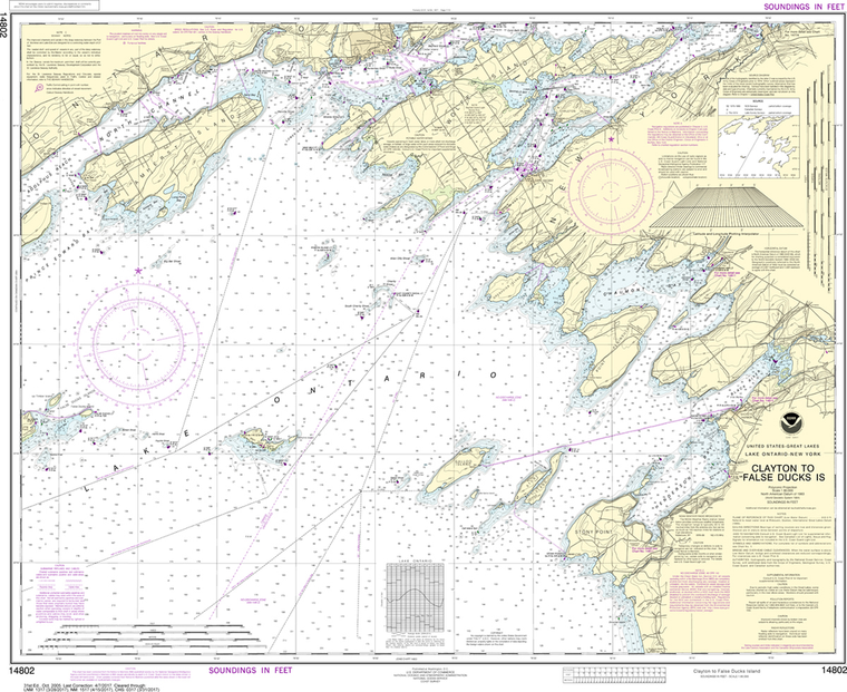
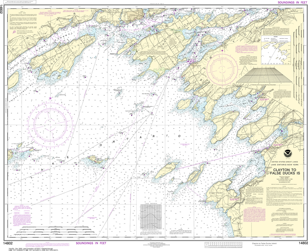
The chart you are viewing is NOT updated weekly and does NOT include all of the latest Notice to Mariners corrections. Region: Great Lakes Latest Edition: 31 Ed. (1-Oct-2005) Last Correction: 2-Jan-2020 Cleared Through: NTM 47/2019...
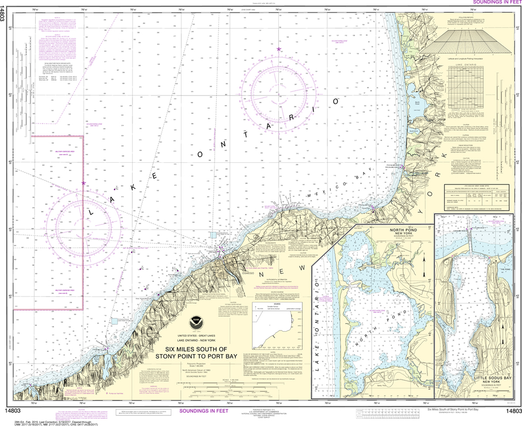
NOAA Chart 14803: Six Miles South of Stony Point to Port Bay, North Pond, Little Sodus Bay
$23.75
The chart you are viewing is NOT updated weekly and does NOT include all of the latest Notice to Mariners corrections. Region: Great Lakes Latest Edition: 28 Ed. (1-Feb-2015) Last Correction: 14-Nov-2018 Cleared Through: NTM 47/2019 (23-Nov-2019)...
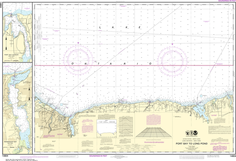
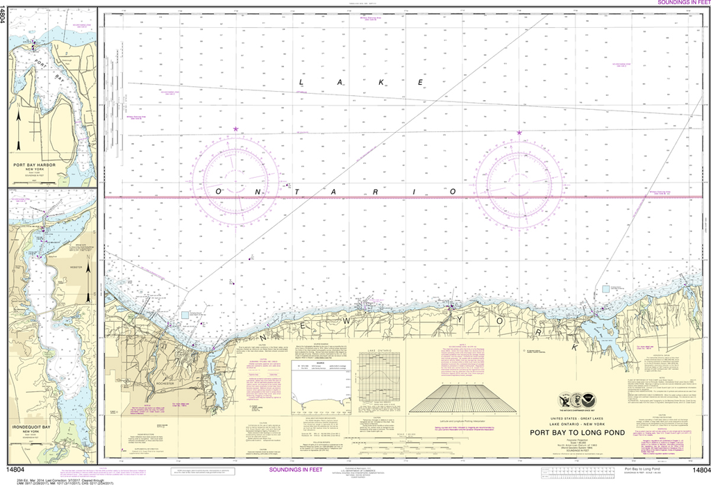
NOAA Chart 14804: Port Bay to Long Pond, Port Bay Harbor, Irondequoit Bay
$23.75
The chart you are viewing is NOT updated weekly and does NOT include all of the latest Notice to Mariners corrections. Region: Great Lakes Latest Edition: 25 Ed. (1-Mar-2014) Last Correction: 30-May-2019 Cleared Through: NTM...
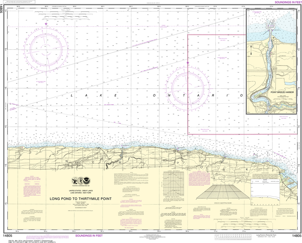
NOAA Chart 14805: Long Pond to Thirtymile Point, Point Breeze Harbor
$23.75
The chart you are viewing is NOT updated weekly and does NOT include all of the latest Notice to Mariners corrections. Region: Great Lakes Latest Edition: 25 Ed. (1-Mar-2014) Last Correction: 30-May-2019 Cleared Through: NTM 47/2019 (23-Nov-2019)...
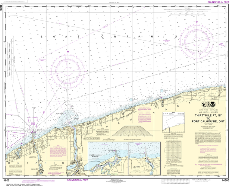
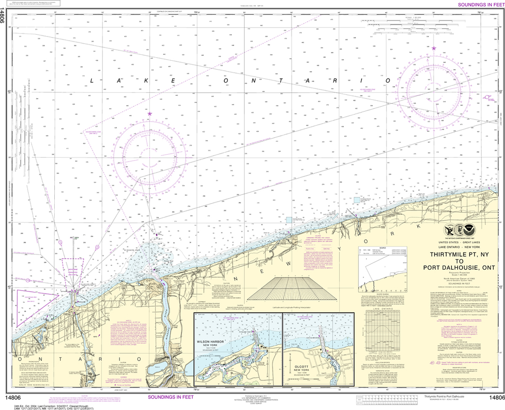
NOAA Chart 14806: Thirtymile Point, NY, to Port Dalhousie, Ont
$23.75
The chart you are viewing is NOT updated weekly and does NOT include all of the latest Notice to Mariners corrections. Region: Great Lakes Latest Edition: 24 Ed. (1-Oct-2004) Last Correction: 7-Dec-2018 Cleared Through: NTM 47/2019 (23-Nov-2019)...