BEFORE PURCHASING DIGITAL CHARTS, PLEASE READ THROUGH THE FAQ PAGE FOR ALL TECHNICAL QUESTIONS, THAT CAN BE FOUND THROUGH THIS LINK: https://www.charts.gc.ca/help-aide/faq-eng.html
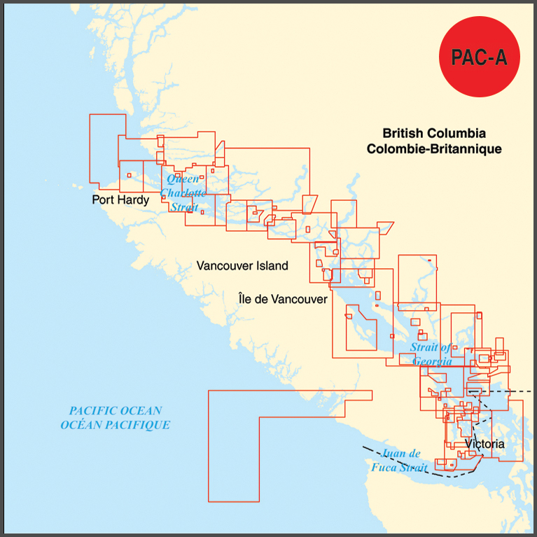
Electronic Navigational Chart (ENC) collection in S-57 format for the east coast of Vancouver Island from Race Rocks to Port Hardy, including Victoria, Vancouver, the Gulf Islands, Sunshine Coast, Desolation Sound, the Broughton Islands, and Queen Charlotte Sound.
The PAC-A collection contains the approximate equal coverage as the following paper charts: 3000, 3001, 3410, 3411, 3412, 3419, 3424, 3440, 3441, 3442, 3443, 3447, 3459, 3462, 3463, 3473, 3475, 3477, 3478, 3479, 3481, 3490, 3491, 3492, 3493, 3494, 3495, 3512, 3513, 3514, 3526, 3527, 3534, 3535, 3536, 3537, 3538, 3539, 3540, 3541, 3542, 3543, 3544, 3545, 3546, 3547, 3548, 3549, 3550, 3552, 3559, 3564, 3598, 3602, and 3921.
Canadian Digital Chart Collections are fulfilled digitally. Once your purchase is complete, a unique transaction code will be provided within 24 hours, allowing you to register, download, and update your digital charts at the CHS Chart Registry Service.